Oberlin's maps and roads
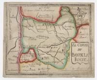
J. F. Oberlin drew this map, made a woodcut to make multiple prints using his hand press, and filled in the place names by hand. With these he gave his parishioners their first visual reference for the physical features and political boundaries of their department in Alsace.
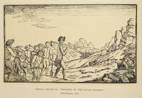
When Oberlin began his ministry in the Ban de la Roche in 1767, the region had no roads to the nearest market town, Rothau, or any other districts. Crop yields were very poor and the people were often badly in need. The local dialect further separated his parishioners from the outside world and from trade. Oberlin addressed these with practical improvements and brought education and the French language to the region. He led by example, shouldering the labor himself until he could train others to be teachers, healers and agriculturists who amended their soils and imported better seed and livestock. He initiated road-building and won the cooperation of the people to complete a road with a bridge to Rothau. Eventually the villagers were able to produce enough crops and goods to begin trade.